Let us know your feedback via our contact form

Spatial Strategy
About > Plan Structure > Spatial Strategy

Vision For Plymouth

Spatial Strategy

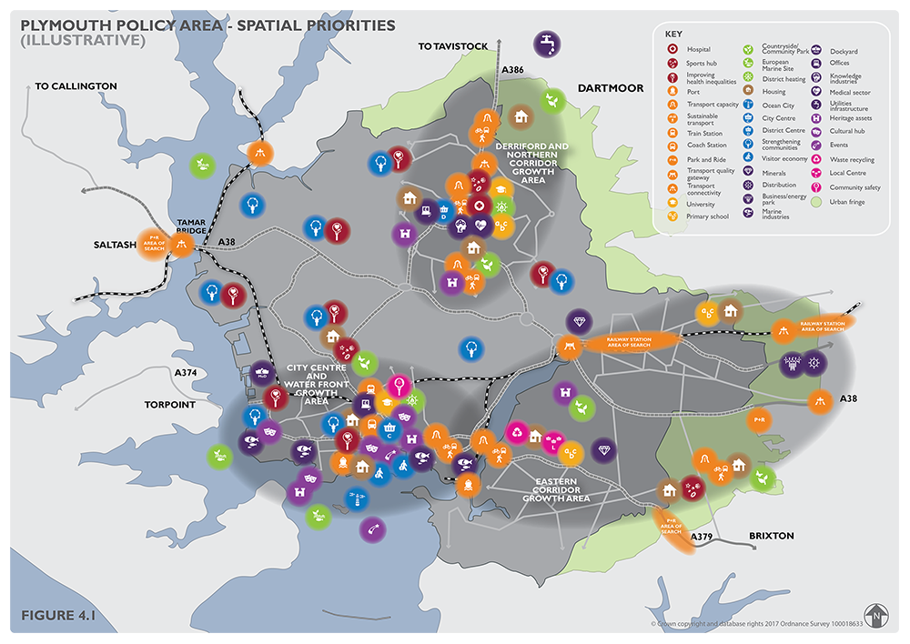
Our Spatial Strategy

The Plymouth Plan's Spatial Strategy is set out in the Plymouth and South West Devon Joint Local Plan (JLP). A key element of this strategy is providing an understanding of how and where change will take place over time, to deliver the vision set out in the Plan, and articulating Plymouth's strategic role within the South West.

This Spatial Strategy plans for the city's growth in the context of Plymouth's wider city region. The JLP covers Plymouth, and the neighbouring authorities of West Devon Borough Council and South Hams District Council (minus Dartmoor National Park Authority). Although Plymouth only accounts for 4 per cent of the JLP's land area, nearly 70 per cent of the residents live in the city, and it provides jobs, health and education facilities and leisure opportunities for all who live in the plan area. Accordingly, Plymouth accommodates most of the growth that will occur in South West Devon over the plan period to 2034, and its growth and success is important to the communities of South Hams and West Devon.

View Plymouth Spatial Strategy section on the interactive Plymouth and South West Devon Joint Local Plan (JLP).

View the interactive Plymouth and South West Devon Joint Local Plan (JLP) website.

How we will meet our development needs

Figure 4.1 - Plymouth Policy Area - Spatial Priorities

The Spatial Strategy section of the Joint Local Plan sets out the overall development need that needs to be met in Plymouth and South West Devon and key principles that will govern how that need will be met. Additionally, it distributes proposed development across two Policy Areas:

The Plymouth Policy Area

This incorporates the administrative area of Plymouth along with Plymouth's urban fringe. Locations that are part of the wider urban area (for example, Woolwell, Langage) and where major development is committed (for example, the new community at Sherford), as well as the city's landscape setting, fall within this policy area.

The Thriving Towns and Villages Policy Area

This incorporates rural South Hams and West Devon, including its market towns, settlements and villages.

How we will support Plymouth’s strategic role

Plymouth plays a key strategic role in providing essential services and facilities at both a sub-regional and regional scale. This role of the city is key to the success of that area.

View the Joint Local Plan's policies relating to the strengthening of Plymouth's strategic role.

Where we will deliver growth

Figure 4.2 - City Centre and the Waterfront Growth Area Vision Diagram

The Spatial Strategy for Plymouth is based on three Growth Areas. These areas have been identified as key to delivering major growth in housing, employment and associated infrastructure to drive Plymouth’s growth.

The City Centre and Waterfront Growth Area

The focus of this area is Plymouth City Centre and regeneration areas along the city's waterfront. Significant amounts of new homes and jobs are proposed, along with the regeneration of the City Centre and the Waterfront to create an environment reflecting Plymouth's aspiration to be one of Europe's finest waterfront cities.

View our policies for the City Centre and Waterfront Growth Area.

Figure 4.4 - Derriford and Northern Corridor Growth Area Vision Diagram

The Derriford and Northern Corridor Growth Area

The focus of this area is the creation of a new heart for the north of the city, providing a range of new homes and jobs, safeguarding the site of Plymouth Airport for future aviation activities, and creating a new commercial heart in Derriford. This area also includes the Woolwell urban extension, which is in the South Hams administrative area. The spine of the area is the A386 Northern Corridor, where strategically important infrastructure projects will improve movements along the corridor to the edge of the policy area and on to Tavistock.

View our policies for the Derriford and Northern Corridor Growth Area.

Figure 4.6 - Eastern Corridor Growth Area Vision Diagram

The Eastern Corridor Growth Area

The focus of this area is ensuring that the delivery of significant numbers of new homes within and on the edge of the city is well integrated into Plymouth's strategic and green infrastructure. The growth area includes Sherford and Langage, where strategically significant numbers of new homes and amounts of employment floorspace are being delivered on sites with the South Hams administrative area, but which should be integrated into Plymouth. The area contains significant green areas such as Saltram Community Park and the new Sherford Community Park, and further large scale housing opportunities in locations such as Saltram Meadow.

View our policies for the Eastern Corridor Growth Area.

Other areas and sites

Clearly not all growth and change will take place in the Growth Areas, and the plan also identifies policies and allocations relating to small sites and other parts of the city.

View our policies for the rest of the city.

It looks like you are using an outdated browser (Internet Explorer) - some features of this site may not function correctly. Please consider updating to a modern browser like Chrome, Firefox or Microsoft Edge,